A Day of Hiking at Peaks of Otter by Kristen
Posted on 2020-03-12
I LOVE the first day it's over 70 degrees in spring!! And this year it was even better because it overlapped with a 2 week spring break from grad school. Originally I had some longer distance adventures planned for spring break, but due to the Coronavirus both fell through. And I'm not complaining, I take full responsibility for doing my part to not spread the disease further. Life could be a lot worse than canceling trips. But I also didn't want to sit in my apartment staring at Kenny while he worked the whole break, so I decided to make the most of some of the beautiful sites close and do some hiking in the Blue Ridge!
Kenny and I both went to high school in Roanoke, and Peaks of Otter is a pretty well known excursion destination. They have a lodge, camping, hiking, and even a winery. But I had never made it out there to go hiking before. I gathered all of my pre-hike information from [here](https://www.hikingupward.com/OVH/PeaksOfOtter/) and found it to be really helpful. I parked at the visitors center around noon and then followed the small path from the visitors center across route 43 and the Blue Ridge Parkway to the Sharp Top Store. The beginning of the path to Sharp Top was right behind the store.

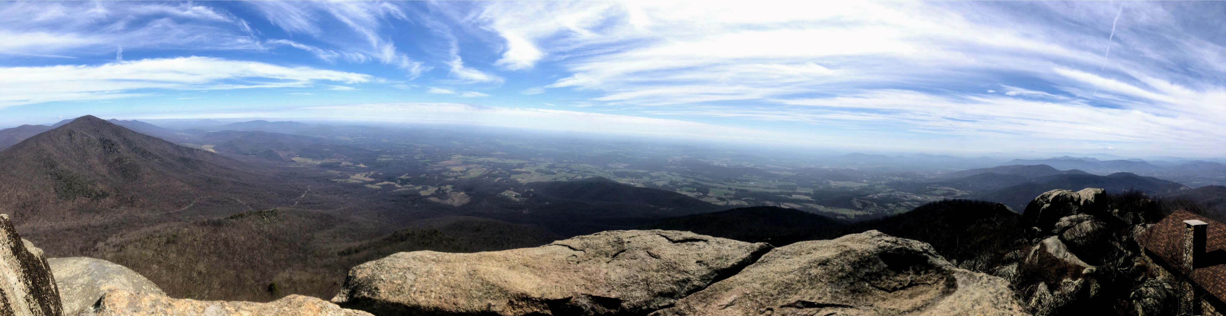
True to report, it was a relatively short but very steep hike. My legs were burning and I was short of breath fairly quickly. The signs advertised a 1.5 mile hike each way although my apple watch showed closer to 2 miles. Trees blocked any great views on the way up, but once you reached the top the reward was well worth it.


After grabbing some lunch I made my way back down fairly quickly (I promised my sister I would be at her house by dinner time and with 3 kids her house gets rowdy when the little ones are hungry). All in all Sharp top took me about 2 hours with lunch, but that was moving pretty quick.
On the way down I went back toward the visitors center and took a right on Lake Trail. I crossed Route 43 again, reached the Lake Trail, and walked past the dam and toward the Ordinary.

From the Ordinary I walked down the paved road to reach the Flat Top Trail. I ran into some deer on the way.

Flat Top Trail was just as brutally steep as Sharp Top was. It made it's way through rocky woods with few switchbacks but lots of inclines. Unlike Sharp Top which was much more trafficked, I didn't see a single other person on the trail or at the parking lot.

The trail flattened out some after the first 1.3ish miles, but it was still challenging. The best view I found up top was going right after the Flat Top summit sign and scrambling on top of some large boulders.

All of the hard work was on the way up. The way down was pretty quick and easy. I jogged about half of it and walked on the rockier pieces. The Flat Top hike took me a little under 2 hours total, which put me back at my car around 4 (in time for a 1 hour drive to Roanoke to make it for dinner!)
Peaks of Otter is definitely worth visiting next time you're around Bedford, VA. Both hikes were challenging in grade, but relatively short. If I had to choose just one, I would pick the views on top of Sharp Top, although the quiet of Flat Top was nice.
Happy hiking!
Search Posts by Tags
Labels
- steep
- blue ridge
- Difficult
- Hiking
I Want More!
Find this post interesting? Check out other posts from this section!